United States metropolitan area

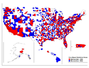
In the United States, a metropolitan area refers to a geographical region with a relatively high population density at its core and close economic ties throughout the area.[1] Such regions are not legally incorporated as a city or town would be, nor are they legal administrative divisions like counties or states. As such the precise definition of any given metropolitan area can vary with the source. A typical metropolitan area is centered around a single large city that wields substantial influence over the region (e.g. Chicagoland). However, some metropolitan areas contain more than one large city with no single municipality holding a dominant position (e.g. Minneapolis – Saint Paul).
Some U.S. government agencies publish definitions of metropolitan areas for accounting and tracking purposes. The most widely used are those published by the Office of Management and Budget. These are used by the U.S. Census Bureau for its demographics statistics as well as many other agencies.
Contents |
Definitions
The U.S. Office of Management and Budget (OMB) defines a set of core based statistical areas (CBSAs) throughout the country. CBSAs are delineated on the basis of a central urban area or urban cluster—a contiguous area of relatively high population density. The counties containing the core urban area are known as the central counties of the CBSA. Additional surrounding counties (known as outlying counties) can be included in the CBSA if these counties have strong social and economic ties to the central counties as measured by commuting and employment. Outlying counties are included in the CBSA if the employment interchange measure (total of in commuting and out commuting) is 25% or more. Note that some areas within these outlying counties may actually be rural in nature. CBSAs are subdivided into metropolitan statistical areas (MSAs) and micropolitan statistical areas based on the population of the core urban area. Under certain conditions, one or more CBSAs may be grouped together to form a larger statistical entity known as a combined statistical area (CSA). Other names, such as Standard Metropolitan Statistical Area and Primary Metropolitan Statistical Area, have been used in the past but are now discontinued.[2] CBSAs are composed of counties and county-equivalents.[3] In New England, because of the greater importance of towns over counties, similar areas are defined based on town units, known as New England City and Town Areas (NECTAs). U.S. census statistics for metropolitan areas are reported based on these definitions.
Definition issues
MSAs are used for official accounting purposes, but they are not the only estimates of metropolitan area populations available. The appropriate boundaries - and therefore population figures - for some metro areas are much debated, and in some cases reputable sources provide figures which differ by millions. The most contentious examples include the Greater Los Angeles Area, the San Francisco Bay Area, and Greater Cleveland. However, some of these boundaries are addressed by CSAs. The official definitions used for the last U.S. Census differed from those for previous censuses, making comparisons difficult even between official figures at different dates (comparing 2000 with 1990, Baltimore was separated from Washington, D.C., but West Palm Beach was combined with Miami-Fort Lauderdale, which made a considerable difference to the rankings of both metros). Care should also be taken when comparing MSA figures with population figures for cities or metro areas outside the U.S., which may be based on substantially different boundary systems and definitions of terms. Additionally, United States MSA boundaries do not stretch into neighboring countries such as Canada or Mexico, so border cities such as Detroit, Buffalo, El Paso and San Diego would count only U.S. population figures.
As of June 2003, there is now an additional classification, that of a “Metropolitan Division.” The term metropolitan division is used to refer to a county or group of closely-tied contiguous counties that serve as a distinct employment region within a metropolitan statistical area that has a population core of at least 2.5 million. While a metropolitan division is a subdivision of a larger metropolitan statistical area, it often functions as a distinct social, economic, and cultural area within the larger region.
See also

- Geography
- United States
- United States Census Bureau
- Office of Management and Budget
- Combined statistical area
- Core Based Statistical Area
- Metropolitan Statistical Area
- Micropolitan Statistical Area
- Demographics of the United States
- Table of United States Combined Statistical Areas (CSA)
- Table of United States Core Based Statistical Areas (CBSA)
- Table of United States Metropolitan Statistical Areas (MSA)
- Table of United States Micropolitan Statistical Areas (µSA)
- Table of United States primary census statistical areas (PCSA)
- List of metropolitan areas by population
- List of regions of the United States
- List of United States cities by population
- List of metropolitan areas in the Americas by population
- List of the largest urban areas of the European Union by population
- Megacity
- World's largest cities
References
- ↑ U.S. Census Bureau Glossary
- ↑ "Metropolitan and Micropolitan Statistical Areas". U.S. Census Bureau. http://www.census.gov/population/www/metroareas/metroarea.html. Retrieved 16 Feb 2010.
- ↑ Census Geographic Glossary, U.S. Census Bureau
External links
- US Census Bureau Population Estimates
- Table 1. Annual Estimates of the Population of Metropolitan and Micropolitan Statistical Areas: April 1, 2000 to July 1, 2005
- U.S. Census 2000 Metropolitan Area Rankings; ranked by population
- U.S. Census 2000 Metropolitan Area Rankings
- Definitions of all Metropolitan Statistical Areas, Metropolitan Divisions
- U.S. Census Metropolitan Area Estimates (1990s)
- U.S. Census Metropolitan and Micropolitan Statistical Area Definitions
|
|||||||||||